
Battista Agnese
(ca. 1500–1564)
Portolan Atlas, on vellum
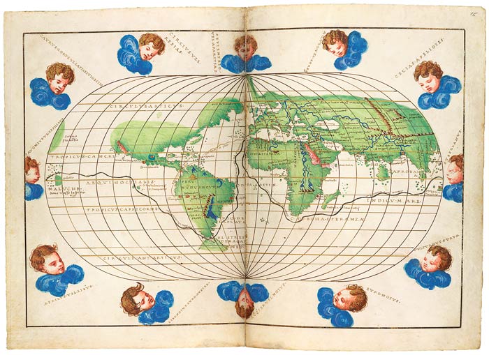
Opening: Map of the World with Magellan's Route 1536–64
Purchased by Pierpont Morgan, 1912
MS M.507
Between 1536 and 1564, the heyday of Italian mapmaking, the cartographer Battista Agnese produced in Venice a number of remarkably accurate and beautifully decorated nautical or "portolan" atlases. About seventy copies are known to exist today. A luxury item, the atlas was unlikely to have been used in practical navigation and was reserved for rich merchants and high-ranking officials.
The map with twelve wind cherubs traces Ferdinand Magellan's sea route for his near circumnavigation of the world (he died before completing it) in 1519–22 along with a route from Spain to Peru. The oval depiction of the world represented a new type of map introduced by Benedetto Bordone's Isolario (Book of Islands).
Travel and the Venetian Empire
By 1500 Venice was the foremost maritime power in Europe as well as an international cultural destination. The city's empire included a dense web of fortified harbors in the eastern Mediterranean stretching along the Dalmatian coast to Crete and Cyprus, which protected its trading interests. In order to cater to the needs of its merchants and naval commanders, Venice became an important center of cartography.
The city's wealth and stability fostered artistic creativity and attracted a host of influential foreign artists, such as Albrecht Dürer, Andrea Schiavone, and El Greco. Not only did these visiting artists invigorate the city's artistic life, they also spread Venetian innovations far beyond the territorial confines of the empire.